1. 'Referring to a Correspondence with Admiral Drury respecting the advantages that might result from a Ship of War occasionally visiting the Gulph of Arabia' Contributor: Commander-in-Chief, East Indies Station (correspondent)Government of Bombay (correspondent) Date: 1810/1810 Language: English Geographic region: Red Sea Extent: 1 item (8 folios)
2. 'Restrictions on the trade in arms, &c., on the Red Sea and on the Somali Coasts' Contributor: Political Resident, Aden (correspondent)India Office, Assistant Secretary to the Political and Secret Department, (correspondent) Date: 1887/1887 Language: English Geographic region: AdenRed SeaSomali Coast Extent: 1 file (4 folios)
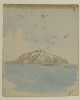
3. ‘Jibel el Teer – Red Sea. 13 Novr 1850’ Contributor: Augustus Fortunatus Bellasis (artist) Date: 1850/1850 Language: English Geographic region: Red SeaSouth Africa Extent: 1 drawing on paper, pasted into volume
4. 'Gibel Tir', by Sir Henry Yule (1820-1899) Contributor: Sir Knight Henry Yule (artist) Date: 1844/1844 Language: English Geographic region: Red Sea Extent: 1 watercolour, pencil and ink drawing on watercolour paper
5. ‘Jibel Jan – 13 Novr 1850.’ Contributor: Augustus Fortunatus Bellasis (artist) Date: 1850/1850 Language: English Geographic region: Red SeaSouth Africa Extent: 1 drawing on paper, pasted into volume
6. ‘Isabera Islands – Red Sea – 13 Novr 1850’ Contributor: Augustus Fortunatus Bellasis (artist) Date: 1850/1850 Language: English Geographic region: Red SeaSouth Africa Extent: 1 drawing on paper, pasted into volume
7. ‘Chart of the Red Sea, Comprising the part above Jiddah, on Mercator’s Projection, Compiled from a Stasimetric Survey, Executed in the Years 1830, 31, 32 & 33 in the Hon.ble Comp.y's Ship Palinurus by Com.der R. Moresby, and Lieu.t T.G. Carless, Indian Navy. T.G. Carless, Draughts.n I.N. Engraved by J.&C. Walker’ Contributor: J & C Walker, engravers (artist)John Walker (publisher)Robert Moresby (surveyor)T. G. Carless (surveyor) Date: 1836/1836 Language: English Geographic region: Red Sea Extent: 1 map on 2 sheets
8. ‘Chart of the Red Sea, from Jiddah, to the Straits of Bab-el-Maneb, Surveyed in the Years 1830, 31, 32 & 33 By Capt.n T. Elvon and Lieu.t H.N. Pinching, and completed in 1833 and 34 by Com.der R. Moresby, Indian Navy. T.G. Carless Lieu.t and Draughts.n I.N. Engraved by J.&C. Walker’ Contributor: J & C Walker, engravers (artist)Robert Moresby (surveyor)T. G. Carless (surveyor)John Walker (publisher) Date: 1836/1836 Language: English Geographic region: Red Sea Extent: 1 map on 2 sheets
9. 'Proposed Transfers of Aden and Somali Coast to Imperial Government; and of Persian Legation to India' Contributor: Foreign Office (author) Date: 1890/1890 Language: English Geographic region: AdenRed SeaSomalia Extent: 1 file (7 folios)
10. 'Memorandum on the Turkish claim to sovereignty over the eastern shores of the Red Sea and the whole of Arabia; and on the Egyptian claim to the whole of the western shore of the same sea, including the African coast from Suez to Cape Guardafui.' Contributor: Foreign Office, Librarian (author) Date: 1874/1874 Language: EnglishFrench Geographic region: Red Sea Extent: 35 folios
11. ‘File 25/3 Agreement between UK and Italy’ Date: 1938/1938 Language: EnglishItalian Geographic region: Suez CanalYemenMediterranean SeaSaudi ArabiaRed Sea Extent: 1 file (23 folios)
12. Red Sea Region, North Africa, ca. 1730 (Raster Image) Date: 201312 Geographic region: AfricaAfrica, NorthRed SeaArabian PeninsulaMediterranean SeaAlgeriaAzerbaijanBahrainCameroonCentral African RepublicChadCongoCongo Democratic Republic of theCyprusDijiboutiEgyptEritreaEthiopiaGaza StripGreeceIranIraqIsraelItalyJordanKenyaKuwaitLebanonLibyaMaltaNigerNigeriaOmanQatarSaudi ArabiaSomaliaSudanSyriaTunisiaTurkeyUgandaUnited Arab EmiratesWest BankYemen84.36247844.728074-5.683373-5.414094