1. ‘Übersichts – Karte Von Iran, Oder West-Hochasien’ Date: 1852/1852 Language: German Geographic region: Iran Extent: 1 map
2. ‘Route from Isfahan by Kermanshah to Muraga and return by Hamadan. Performed under Orders of Brigr. Genl. Malcolm by Lieut. E. Frederick of the Bombay Military Establishmt. AD. 1810’ Contributor: John Garstin (signer) Date: 1810/1810 Language: EnglishLatin Geographic region: Iran Extent: 1 map sheet
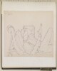
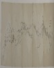
3. ‘Capt C. at Marshag. May 22nd 71’ Contributor: Jeffery Charles Amherst (artist) Date: 1871/1871 Language: English Geographic region: AdenCentral AsiaAvaBengalBombayBrazilBurmaCanadaCantonCentral IndiaChinaDelhiFort WilliamHong KongHyderabad StateIndiaIranIrelandJavaMadagascarMadrasMalaccaNagpurOudhPenangPhilippinesRajputanaRamreeRussiaShahpurSicilySingaporeBharatpur Extent: 1 drawing; pencil on paper, pasted into volume
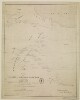
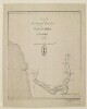
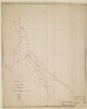
4. ‘Route map of the special mission to Seistan and Mekran, from Ispahan to Gwadur by Quarter Master Sergeant David Bower, Royal Engineers. To accompany the Journal of Capn. C. Bean Euan Smith, Personal Assistant to Major-General J.T. Goldsmid, C.B.’ Contributor: Trelawney William Saunders (publisher) Date: 1872/1872 Language: English Geographic region: Iran Extent: 1 map sheet
5. ‘Route map of the special mission to Seistan and Mekran, from Ispahan to Gwadur by Quarter Master Sergeant David Bower, Royal Engineers. To accompany the Journal of Capn. C. Bean Euan Smith, Personal Assistant to Major-General J.T. Goldsmid, C.B.’ Contributor: Trelawney William Saunders (publisher) Date: 1872/1872 Language: English Geographic region: Iran Extent: 1 map sheet
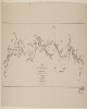
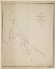
6. ‘Route map of the special mission to Seistan and Mekran. By Quarter Master Sergeant David Bower, Royal Engineers’ Date: 1872/1872 Language: English Geographic region: Iran Extent: 1 map sheet
7. ‘Map of a route from Bushire to Bagdad Dedicated with submission to Captn. Sir Charles Malcolm R.N. By his Obedient Servant W.H. Wyburd I.N.’ Contributor: Charles Malcolm (dedicatee) Date: 1833/1833 Language: English Geographic region: IranIraq Extent: 1 map sheet
8. ‘Sketch of Lieutt. Snodgrass’s Route from Bushire to Shiraz, via Feruzabad, A.D. 1810’ Contributor: John Garstin (signer) Date: 1810/1810 Language: English Geographic region: Iran Extent: 1 map sheet
9. ‘Route of Lieut. McDonald 12th N.I. Ensign Monteith Engineers. Performed by Order of Brigadier General Malcolm Ambassador to the Court of Persia’ Contributor: John Garstin (signer) Date: 1806/1816 Language: English Geographic region: Iran Extent: 1 map sheet
10. ‘Route of Lieut. McDonald 12th N.I. Ensign Monteith Engineers. Performed by Order of Brigr. Genl. Malcolm Embassador to the Court of Persia. W. Monteith Ensgn Engineers' Contributor: John Garstin (signer) Date: 1811/1811 Language: English Geographic region: Iran Extent: 1 map sheet
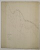
11. 'Sketch Map of the Gulf of Persia' Date: 1863/1863 Language: English Geographic region: East AfricaArabian PeninsulaCentral AsiaBaroda StateIranKalat StateMysore StatePersian GulfRajputanaRiyadhRussiaSindUdaipur StateZanzibarGohadMuscat Extent: 1 map
12. Fragment of wall painting: female with a mouth cover (padam) 8.27 x 9.61 in. (21.01 x 24.41 cm) Date: 600 - 700ca. 7th century A.D. Geographic region: IranKuh-i Khwaja Time period: Sasanian Medium: Stucco, paint, plaster Extent: 8.27 x 9.61 in. (21.01 x 24.41 cm)
13. Fragment of wall painting: male head 13.39 x 9.45 in. (34.01 x 24 cm) Date: 600 - 700ca. 7th century A.D. Geographic region: IranKuh-i Khwaja Time period: Sasanian Medium: Stucco, plaster, paint Extent: 13.39 x 9.45 in. (34.01 x 24 cm)
14. Indian Ocean Region, ca. 1690 (Raster Image) Date: 201110 Geographic region: AfghanistanAlgeriaAngolaArmeniaAustraliaAzerbaijanBahrainBangladeshBhutanBotswanaBritish Indian Ocean TerritoryBruneiBurmaBurundiCambodiaCameroonCentral Africian RepublicChadChinaChristmas IslandCocos (Keeling) IslandsComorosCongo, Democratic Republic of theCongo, Republic of theDjiboutiEgyptEritreaEthiopiaGabonGlorioso IslandsGuamIndiaIndonesiaIranIraqIsraelJapanJordanJuan de Nova IslandKazakhstanKenyaKuwaitKyrgyzstanLaosLesothoLibyaMadagascarMalawiMalaysiaMaldivesMauritiusMayotteMozambiqueNamibiaNepalNigerNigeriaNorth KoreaNorthern Mariana IslandsOmanPakistanPalauPapua New GuineaPhilippinesQatarReunionRwandaSaudi ArabiaSeychellesSingaporeSomaliaSouth AfricaSouth KoreaSri LankaSudanSwazilandSyriaTajikistanTanzaniaThailandTimor-LesteTurkeyTurkmenistanUgandaUnited Arab EmiratesUzbekistanVietnamYemenZambiaZimbabweIndian OceanAsiaSouth AsiaSoutheast AsiaAfrica, East177.31452253.283629-65.180727-13.682351
15. Middle East and South Asia, 1903 (Raster Image) Date: 201112 Geographic region: AfghanistanAlbaniaArmeniaAzerbaijanBahrainBangladeshBhutanBulgariaBurmaChinaCyprusDjiboutiEgyptEritreaEthiopiaGaza StripGeorgiaGreeceIndiaIranIraqIsraelJordanKazakhstanKuwaitKyrgyzstanLebanonLibyaMacedoniaNepalOmanPakistanQatarRomaniaRussiaSaudi ArabiaSerbiaSomaliaSri LankaSudanSyriaTajikistanTurkeyTurkmenistanUkraineUnited Arab EmiratesUzbekistanWest BankMiddle EastSouth Asia121.20188270.212732-15.812745-4.782745
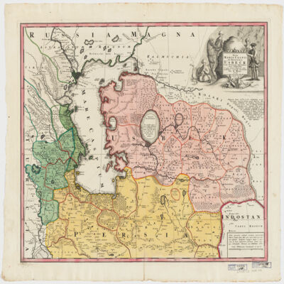
16. Nova Maris Caspii et regionis Usbeck, cum provincijs adjacentibus vera delineatio Creator: Maas, Abraham. (المنشئ) Date: Date Issued: 1735 Language: Latin Geographic region: Place of Production: gw, Germany, [Nuremberg]UzbekistanIranCaspian Sea RegionAsia, Central Extent: 1 map : hand col. ; 47 x 57 cm.
17. Ottoman Empire, 1899 (Raster Image) Date: 201001 Geographic region: ArmeniaGreeceIranIraqIsraelJordanLebanonSyriaTurkeyWest Bank48.17457342.99657629.34755923.414883
18. Ottoman Empire, ca. 1790 (Raster Image) Date: 201001 Geographic region: AlbaniaAlgeriaArmeniaAustriaAzerbaijanBahrainBosnia & HerzegovinaBulgariaCroatiaCyprusEgyptEritreaFranceGaza StripGeorgiaGreeceHungaryIranIraqIsraelItalyJordanKazakhstanKuwaitLebanonLibyaMacedoniaMaltaMoldovaMontenegroOmanPolandQatarRomaniaRussiaSan MarinoSaudi ArabiaSerbiaSlovakiaSloveniaSomaliaSudanSyriaTunisiaTurkeyTurkmenistanUkraineUnited Arab EmiratesUzbekistanVatican CityWest BankYemen89.99419957.5464463.534051-14.597445
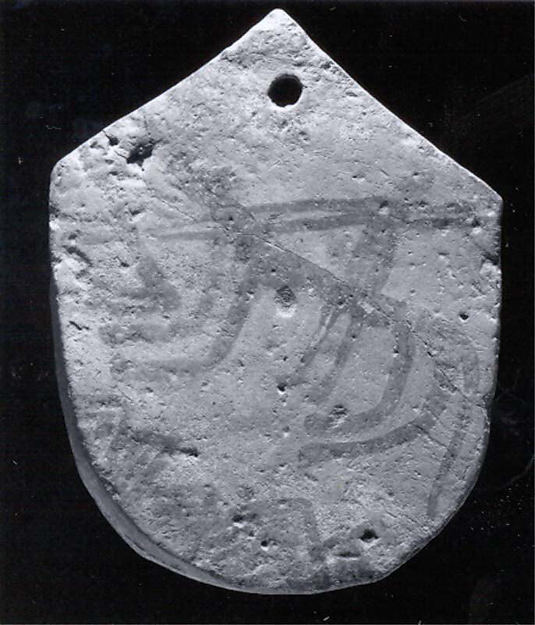
19. Plaque 6.1 x 4.84 in. (15.49 x 12.29 cm) Date: -1000 - -11st millennium B.C. Geographic region: Iran Time period: Iron Age Medium: Clay Extent: 6.1 x 4.84 in. (15.49 x 12.29 cm)
20. Prince Yahya Creator: Muhammad Hasan Date: ca. 1830s Geographic region: Iran Time period: Qajar Period Medium: Oil on canvas Extent: 67 x 35 in. (170.2 x 88.9 cm)
21. Red Sea Region, North Africa, ca. 1730 (Raster Image) Date: 201312 Geographic region: AfricaAfrica, NorthRed SeaArabian PeninsulaMediterranean SeaAlgeriaAzerbaijanBahrainCameroonCentral African RepublicChadCongoCongo Democratic Republic of theCyprusDijiboutiEgyptEritreaEthiopiaGaza StripGreeceIranIraqIsraelItalyJordanKenyaKuwaitLebanonLibyaMaltaNigerNigeriaOmanQatarSaudi ArabiaSomaliaSudanSyriaTunisiaTurkeyUgandaUnited Arab EmiratesWest BankYemen84.36247844.728074-5.683373-5.414094
22. Third of 3 Journals (1867–73) of Jeffery Charles Amherst (1844–77), fourth son of 2nd Earl Amherst Contributor: Jeffery Charles Amherst (artist) Date: 1870/1876 Language: English Geographic region: Central AsiaAvaBengalBombayBrazilBurmaCanadaCantonCentral IndiaChinaDelhiFort WilliamHong KongHyderabad StateIndiaIranIrelandJavaMadagascarMadrasMalaccaNagpurOudhPenangPhilippinesRajputanaRamreeRussiaShahpurSicilySingaporeBharatpur Extent: 1 case bound, unpublished volume (unknown number of pages), illustrated with 49 watercolour, pencil and pen and ink drawings
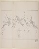
23. A photographic copy of 'Route map of the special mission to Seistan and Mekran by Quartermaster-Sergeant David Bower, Royal Engineers' Date: 1872/1872 Language: English Geographic region: Iran Extent: 1 map sheet
24. ‘Aden – Oct 22nd /71’ Contributor: Jeffery Charles Amherst (artist) Date: 1871/1871 Language: English Geographic region: AdenCentral AsiaAvaBengalBombayBrazilBurmaCanadaCantonCentral IndiaChinaDelhiFort WilliamHong KongHyderabad StateIndiaIranIrelandJavaMadagascarMadrasMalaccaNagpurOudhPenangPhilippinesRajputanaRamreeRussiaShahpurSicilySingaporeBharatpur Extent: 2 drawings; watercolour and pencil on paper, pasted into volume
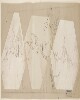
25. Draft pencil sketches of Nejd [Najd] territory Contributor: Sir Knight Lewis Pelly (creator)William Henry Colvill (creator)Sir Henry Bartle Edward Frere (creator)Sir Knight Frederic John Goldsmid (creator)Sir Knight William Henry Rodes Green (creator)Sir Knight Robert Phayre (creator)1st Earl of Northbrook Thomas George Baring (creator)Sir Knight William Lockyer Merewether (creator)William Gifford Palgrave (creator)Sir Knight Charles Umpherston Aitchison (creator) Date: 1865/1866 Language: EnglishArabic Geographic region: Shatt al ʻArabKoweitBaroda StateIranPersian GulfRajputanaRiyadhRussiaSindMuscatZanzibarAl-Hasa Extent: 2 folios