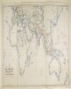
1. ‘MAP SHOWING THE STEAM COMMUNICATION AND OVERLAND ROUTES between ENGLAND, INDIA, CHINA & AUSTRALIA. Drawn & Engraved by J. Walker’ Contributor: William H Allen and Company, booksellers and publishers, London (publisher) Date: 1853/1853 Language: English Geographic region: EuropeAsiaAfricaAustralia Extent: 1 map
2. Indian Ocean Region, ca. 1690 (Raster Image) Date: 201110 Geographic region: AfghanistanAlgeriaAngolaArmeniaAustraliaAzerbaijanBahrainBangladeshBhutanBotswanaBritish Indian Ocean TerritoryBruneiBurmaBurundiCambodiaCameroonCentral Africian RepublicChadChinaChristmas IslandCocos (Keeling) IslandsComorosCongo, Democratic Republic of theCongo, Republic of theDjiboutiEgyptEritreaEthiopiaGabonGlorioso IslandsGuamIndiaIndonesiaIranIraqIsraelJapanJordanJuan de Nova IslandKazakhstanKenyaKuwaitKyrgyzstanLaosLesothoLibyaMadagascarMalawiMalaysiaMaldivesMauritiusMayotteMozambiqueNamibiaNepalNigerNigeriaNorth KoreaNorthern Mariana IslandsOmanPakistanPalauPapua New GuineaPhilippinesQatarReunionRwandaSaudi ArabiaSeychellesSingaporeSomaliaSouth AfricaSouth KoreaSri LankaSudanSwazilandSyriaTajikistanTanzaniaThailandTimor-LesteTurkeyTurkmenistanUgandaUnited Arab EmiratesUzbekistanVietnamYemenZambiaZimbabweIndian OceanAsiaSouth AsiaSoutheast AsiaAfrica, East177.31452253.283629-65.180727-13.682351
3. Oceania and Australasia, 1773 (Raster Image) Date: 200905 Geographic region: Southern HemisphereAustraliaAustralasiaOceaniaPacific Ocean180.00000047.083860-70.929153-180.000000
4. Oceania, 1836 (Raster Image) Date: 200911 Geographic region: OceaniaPacific OceanAustraliaSoutheast Asia180.00000046.786127-64.376995-180.000000
5. SRTM30 enhanced global map : Slope Date: 2003 Geographic region: EarthEastern HemisphereWestern HemisphereNorthern HemisphereSouthern HemisphereAfricaAsiaAustraliaEuropeNorth AmericaSouth AmericaPolar regions180.00000090.000000-90.000000-180.000000 Extent: E. Rodríguez, et. al
6. World Map Showing Routes of Exploration and Discovery, 1850 (Raster Image) Date: 200911 Geographic region: EarthNorthern HemisphereSouthern HemisphereEastern HemisphereWestern HemisphereAfricaAsiaAustraliaEuropeNorth AmericaSouth AmericaArctic regions180.00000086.438634-84.990843-180.000000
7. World Map Showing Routes of Exploration and Discovery, 1853 (Raster Image) Date: 200910 Geographic region: EarthNorthern HemisphereSouthern HemisphereEastern HemisphereWestern HemisphereAfricaAsiaAustraliaEuropeNorth AmericaSouth AmericaArctic regions180.00000082.204539-82.110711-180.000000
8. World Map, 1654 (Raster Image) Date: 201404 Geographic region: EarthNorthern HemisphereSouthern HemisphereEastern HemisphereWestern HemisphereAfricaAsiaAustraliaEuropeNorth AmericaSouth AmericaArctic regions18090-90-180
9. World Map, 1725 (Image 2 of 2) (Raster Image) Date: 200910 Geographic region: EarthEastern HemisphereAfricaAsiaAustraliaEuropeSouth AmericaArctic regions171.98918283.865163-68.289741-65.093564
10. World Map, 1801 (Raster Image) Date: 200901 Geographic region: EarthNorthern HemisphereSouthern HemisphereEastern HemisphereWestern HemisphereAfricaAsiaAustraliaEuropeNorth AmericaSouth AmericaArctic regions180.00000084.263421-78.259774-180.000000
11. World Map, ca. 1774 (Raster Image) Date: 200910 Geographic region: EarthNorthern HemisphereSouthern HemisphereEastern HemisphereWestern HemisphereAfricaAsiaAustraliaEuropeNorth AmericaSouth AmericaArctic regions180.00000084.976331-76.321183-180.000000
12. PZ 5662/1939 'Treatment of Enemy Consuls in British territory, other than India, on the outbreak of war' Contributor: Governor of Burma (correspondent)Government of Southern Rhodesia (correspondent)Government of the Union of South Africa (correspondent)Government of New Zealand (correspondent)Government of the Commonwealth of Australia (correspondent)Government of Canada (correspondent)Secretary of State for the Colonies, United Kingdom (correspondent)Secretary of State for India and Burma, United Kingdom (correspondent)Indian Political Service, External Affairs Department (recipient)Dominions Office (correspondent) Date: 1939/1939 Language: English Geographic region: Southern RhodesiaNew ZealandCanadaBurmaIndiaAustralia Extent: 1 file (53 folios)