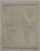
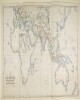
Imprint:Calcutta, Jan.y 1834. J.B. Tassin lith.Distinctive Features:Relief shown by hachures.Map shows various routes between places of interest including caravan and pilgrim routes, with estimated journey times and location of wells reported. Notations concerning regions and their topography cover the face of the map. Includes a key to symbols and dedication from J.B. Tassin to Lord William Cavendish Bentinck Governor General and Commander in Chief in India.1 mapDimensions:743 x 1047 mm, on sheet 868 x 1158 mm
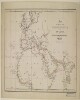
Distinctive Features:Unsigned and undated.Land routes shown in blue with sea routes and waterways coloured red.1 map sheetDimensions:327 x 562 mm, on sheet 407 x 646 mm
Imprint:London, Wm. H. Allen & Co., 13 Waterloo Place, S.W.Distinctive Features:Includes two insets: ‘ROUTES between MEDITERRANEAN and RED SEA on an Enlarged Scale’ and ‘ROUTES between MEDITERRANEAN, BLACK SEA and PERSIAN GULF on an Enlarged Scale’.Routes shown in colour with a list of shipping companies and a key at bottom centre.1 mapDimensions:677 x 1237 m, on sheet 732 x 1296 mm
This map shows Turkey where it is included in Europe and features the Straits, Smyrna [Izmir], and islands. The map indicates boundaries and relief with contours.The map includes a printing statement which reads '(B 16478) WT 18378-212.5050.10/20.H&S,LTD.'1 mapMaterials: Printed in colour on paper with manuscript additions in coloured inkDimensions: 495 x 430mm, on sheet 630 x 475mm
Imprint:London, Connell Litho. 37 Castle St. Holborn E.C.Distinctive Features:Outline map showing the completed and proposed railway scheme in Europe and Asia, with lines coloured for reference and explained in a key provided in the lower centre of sheet.Below title the note: London, Brussels, Paris, Berlin Vienna and Constantinople with Teheran, Herat, Kandahar, Sukkur, Lahore, Bombay, Madras and Calcutta and eventually with Burmah and China.1 mapDimensions:630 x 1147 mm; on sheet 676 x 1220 mmFoliation:The map sheet has been foliated in the front top right hand corner of the folio with a pencil number enclosed in a circle.
This layer is a georeferenced raster image of the historic paper map entitled: Nova Africae tabula, auctore Jodoco Hondio. It was published by Excusum in aedibus auctoris ca. between 1611 and 1612. Scale [ca. 1:24,000,000]. Covers Africa and small portions of Europe and the Middle East. Map in Latin.The image inside the map neatline is georeferenced to the surface of the earth and fit to the Africa Sinusoidal projected coordinate system. All map collar and inset information is also available as part of the raster image, including any inset maps, profiles, statistical tables, directories, text, illustrations, index maps, legends, or other information associated with the principal map. This map shows features such as drainage, cities and other human settlements, territorial boundaries, shoreline features, and more. Relief shown pictorially. Includes notes.This layer is part of a selection of digitally scanned and georeferenced historic maps from the Harvard Map Collection. These maps typically portray both natural and manmade features. The selection represents a range of originators, ground condition dates, scales, and map purposes.Historic paper maps can provide an excellent view of the changes that have occurred in the cultural and physical landscape. The wide range of information provided on these maps make them useful in the study of historic geography, and urban and rural land use change. As this map has been georeferenced, it can be used in a GIS as a source or background layer in conjunction with other GIS data.None planned
This layer is a georeferenced raster image of the historic paper map entitled: Africa vetus, autore N. Sanson. It was published by J. Cóvens & C. Mortier ca. 1725. Scale [ca. 1:25,000,000]. Covers Africa and small portions of Europe and the Middle East. Map in Latin. The image inside the map neatline is georeferenced to the surface of the earth and fit to the Africa Sinusoidal projected coordinate system. All map collar and inset information is also available as part of the raster image, including any inset maps, profiles, statistical tables, directories, text, illustrations, index maps, legends, or other information associated with the principal map. This map shows features such as drainage, cities and other human settlements, territorial boundaries, shoreline features, and more. Relief shown pictorially. This layer is part of a selection of digitally scanned and georeferenced historic maps from the Harvard Map Collection. These maps typically portray both natural and manmade features. The selection represents a range of originators, ground condition dates, scales, and map purposes.Historic paper maps can provide an excellent view of the changes that have occurred in the cultural and physical landscape. The wide range of information provided on these maps make them useful in the study of historic geography, and urban and rural land use change. As this map has been georeferenced, it can be used in a GIS as a source or background layer in conjunction with other GIS data.None planned
"Text in image: Moubarek Dépage. SoLidarité Avec l'EGYPTE. DIGNITY HUMANITY. GAME OVER MOBARAK. Corruption Poverty 40%. Translation of text in image: SoLidarity with EGYPT. Photos and videos of protestors and activities taking place in Tahrir Square during the last week of 18 days from Feb 4-112011. Also includes photos from GenevaSwitzerland of demonstrations taking place from Jan 28-Feb 32011."
"Text in image: Moubarek Dépage. SoLidarité Avec l'EGYPTE. GAME OVER MOBARAK. Translation of text in image: SoLidarity with EGYPT. Photos and videos of protestors and activities taking place in Tahrir Square during the last week of 18 days from Feb 4-112011. Also includes photos from GenevaSwitzerland of demonstrations taking place from Jan 28-Feb 32011."
Text in image: Police brutality. Corruption Poverty 40%. Photos and videos of protestors and activities taking place in Tahrir Square during the last week of 18 days from Feb 4-11, 2011. Also includes photos from Geneva, Switzerland of demonstrations taking place from Jan 28-Feb 3, 2011.