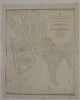
Imprint:Calcutta, Jan.y 1834. J.B. Tassin lith.Distinctive Features:Relief shown by hachures.Map shows various routes between places of interest including caravan and pilgrim routes, with estimated journey times and location of wells reported. Notations concerning regions and their topography cover the face of the map. Includes a key to symbols and dedication from J.B. Tassin to Lord William Cavendish Bentinck Governor General and Commander in Chief in India.1 mapDimensions:743 x 1047 mm, on sheet 868 x 1158 mm
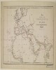
Distinctive Features:Unsigned and undated.Land routes shown in blue with sea routes and waterways coloured red.1 map sheetDimensions:327 x 562 mm, on sheet 407 x 646 mm
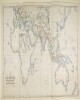
Imprint:London, Wm. H. Allen & Co., 13 Waterloo Place, S.W.Distinctive Features:Includes two insets: ‘ROUTES between MEDITERRANEAN and RED SEA on an Enlarged Scale’ and ‘ROUTES between MEDITERRANEAN, BLACK SEA and PERSIAN GULF on an Enlarged Scale’.Routes shown in colour with a list of shipping companies and a key at bottom centre.1 mapDimensions:677 x 1237 m, on sheet 732 x 1296 mm
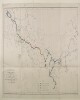
Imprint:London, Connell Litho. 37 Castle St. Holborn E.C.Distinctive Features:Outline map showing the completed and proposed railway scheme in Europe and Asia, with lines coloured for reference and explained in a key provided in the lower centre of sheet.Below title the note: London, Brussels, Paris, Berlin Vienna and Constantinople with Teheran, Herat, Kandahar, Sukkur, Lahore, Bombay, Madras and Calcutta and eventually with Burmah and China.1 mapDimensions:630 x 1147 mm; on sheet 676 x 1220 mmFoliation:The map sheet has been foliated in the front top right hand corner of the folio with a pencil number enclosed in a circle.
This layer is a georeferenced raster image of the historic paper map entitled: Nova tabula Indiae Orientalis. It was published by Carolus Allard excudit, between 1690 and 1710. Scale [ca. 1:5,500,000]. Covers the Indian Ocean Region. Map in Latin. The image inside the map neatline is georeferenced to the surface of the earth and fit to the World Miller Cylindrical projected coordinate system. All map collar and inset information is also available as part of the raster image, including any inset maps, profiles, statistical tables, directories, text, illustrations, index maps, legends, or other information associated with the principal map. This map shows features such as drainage, roads, cities and other human settlements, territorial boundaries, shoreline features, and more. Relief shown pictorially.This layer is part of a selection of digitally scanned and georeferenced historic maps from the Harvard Map Collection. These maps typically portray both natural and manmade features. The selection represents a range of originators, ground condition dates, scales, and map purposes.Historic paper maps can provide an excellent view of the changes that have occurred in the cultural and physical landscape. The wide range of information provided on these maps make them useful in the study of historic geography, and urban and rural land use change. As this map has been georeferenced, it can be used in a GIS as a source or background layer in conjunction with other GIS data.None planned
Shelfmark: Ann Arbor, University of Michigan, Special Collections Research Center Isl. Ms. 606Origin: As appears in colophon on fol.192b, copied in Badahl (Egypt) by Aḥmad ibn Muḥammad ibn ʻAbd al-Dāʼim ibn Muḥammad ibn Sulaymān al-Badahlī al-Shāfiʻī. Transcription completed ("kān al-farāgh min naskhih...") during Jumādá I 990 [May-June 1582].Accompanying materials: a. Inventory cataloguing slip in hand of Winifred Smeaton Thomas. -- b. Acquisitions slip from Yahuda.Former shelfmark: From inner front cover and spine label, "IL 108" (likely supplied by Yahuda, see acquisitions slip).Binding: Pasteboard covered in paper printed with a red, black and white vegetal pattern; Type III binding (without flap); not original to codex; worn but intact.Support: non-European laid paper; at least three different papers are used; the paper of the 14th and 15th quires is notable for being quite thin; at least one of these papers can be described as 'Mamluk,' having 3 sets of 2 horizontal chain lines, with the chain lines roughly 12 mm. and groups roughly 40 mm. apart; roughly 7 laid lines per cm. (see fol. 37 where the paper's features are readily apparent).Decoration: On fol.3b, circular world map painted chiefly in blue and brown with a border of green lobes (representing the belt of mountains surrounding the Earth) and richly labeled with Mecca at the center, the Encircling Ocean, and other places, bodies of water, etc. marked in black and red ink; portions lost due to trimming; on fol.14a a framed chart with partial table of contents; on fol.51b a diagram in black and red ink for finding the direction of Makkah based on one's location with illustration of the Kaʻbah at the center; on fol.191a a table in black and red ink for use in calculating dominance using the numerical values of names; text rubricated with section headings, textual dividers, etc. in red.Script: Naskh; a small, clear hand with extremely vertical lāms and alifs, generally free of serifs, shaddah is generally marked; hamzah and waṣlah not marked; ihmāl signs often used over unpointed letters; a larger naskh is frequently used for section headings; thoroughly vocalized.Layout: Written in 19 lines per page; frame-ruled (using a misṭarah) though oddly at times, see fol. 151a where the writing does not extend to the end of the rulings.Collation: i, 1 (1), III (7), 18 V (187), III (193) ; chiefly quinions; quire numbering in the form of Hindu-Arabic numerals is present for quires 13, 14, 17, 18, 19 in the top outer corner of the first folio of each quire; catchwords present; pagination in pencil, Western numerals (referenced in cataloguing).Colophon: "Scribal," rectangular, reads: "وبتمامه تم الكتاب بحمد الله الكريم الوهاب كان الفراغ من نسخه قبل الظهر ببدهل في يوم الاثنين المبارك عشري شهر جمادى الاولى من شهور سنة تسعين وتسعماية على يد افقر عباد الله تعالى واحوجهم الى عفو ربه ومغفرته ورضوانه العبد الفقير احمد بن محمد بن عبد الدائم بن محمد بن سليمان البدهلي الشافعي"Explicit: "و هذه خاتمة الارجوزة وما حوت من حكم عزيزة"Incipit: "قل لا يعلم من في السماوات والأرض الغيب إلا الله الحمد لله غافر الذنب قابل التوب شديد العقاب عالم الغيب ... وبعد فان خالق الخلق والبدية ومن له الارادة و المشيئة قد ميز الملوك والرعاة عن من دونهم من الرعية"Title from inscription on front flyleaf.Ms. codex.4. fol. 191a-192b : Faṣl fī mawḍūʻ al-shaṭranj / Ibn al-Habbārīyah [?].3. fol.191a : Hādhā jadwal fīhi ḥisāb al-ghālib wa-al-maghlūb.2. fol.187b-191a : Qilādat al-durr al-manthūr fī dhikr al-baʻth wa-al-nushūr / ʻAbd al-ʻAzīz al-Dīrīnī.1. fol.1a-187b : Kharīdat al-ʻajāʼib wa farīdat al-gharāʼib / Zayn al-Dīn ʻUmar ibn al-Muẓaffar Ibn al-Wardī [?].Cosmography, mainly plagiarized from the Jāmiʻ al-funūn wa-salwat al-maḥzūn of Najm al-Dīn al-Ḥarrānī (ca.732/1332). Authorship of the Kharīdah is disputed. It is often attributed to Abū Ḥafṣ Sirāj al-Dīn ʻUmar ibn Muḥammad Ibn al-Wardī (d.861/1457) whose name al-Ziriklī gives as al-Wurūdī, though in this ms. it is ascribed to Zayn al-Dīn Ibn al-Wardī (d.749/1349). It has also been attributed to an ʻUmar Ibn al-Wardī al-Subkī. (see EI2 "Ibn al- Wardī , Sirādj al-Dīn Abū Ḥafṣ ʻUmar" and Sellheim, R. Materialen zur arabischen Literaturgeschichte, t. I, no. 49 for more on this matter of disputed authorship). The text concludes with excerpts from a poem on the resurrection, a table for numerological calculations of dominance using names, and verses on the game of chess. Description provided by Noah Gardiner.
"This manuscriptis a historical dissertation on the lives of members of King Herod I's family during the Roman Empire's occupation of Judea from 37 B.C.E. to 4 C.E. Herod the Great is one of the most important characters in Jewish history. He was appointed king of Judea by the Roman Empire in 37 B.C.E. and ruled until his death in 4 C.E. Herodin an attempt to prove his Jewish faithmarried his second wifeMiriamnein 45 B.C.E. Miriamne was the Hasmonean Alexandrosand thus one of the last heirs to the Hasmonean dynasty of Judea. Although Herod is fabled to have loved the reknown beautyhe murdered her brotherAristobulusand Mariamne was executed in 29 B.C. JealousHerod murdered his two sons by MiriamneAlexandros and Aristobulus in 7 B.C.E."
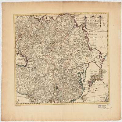
ampliss viri D. N. Witsen pro majori parte aliis auctoribus excerpta et dita per F. de Witt.Covers Northeastern Russia, China, Korea, Japan, Turkestan, Kazakhstan, Tajikistan, Kyrgyzstan, Mongolia, Uzbekistan, Afghanistan, Pakistan and portions of Iran, India, China.Relief shown pictorially.Colored in outline.Appears in: Atlas nouveau contenant toutes les parties du monde, où sont exactement marqués les empires, monarchies, royaumes, états républiques &c; le tout recueilli par les meilleurs géographes. [1683-1761]. Vol. 8, map no.108.In Latin with place names in Russian, Turkish, Persian and Arabic in Latin script.Electronic reproduction. Cambridge, Mass. : Harvard College Library Digital Imaging Group, 2009. (Open Collections Program at Harvard University. Islamic Heritage Project). Copy digitized: Map Coll (Pusey) : MAP-LC G7400 1725 .W5.