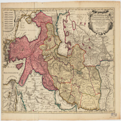
13. Regnum Persicum Imperium Turcicum in Asia Russorum Provinciae ad Mare Caspiumaliaequae regiones finitimae, item Ponti Euxini, Maris Caspii, ac Sinus Persici novissimae ac fidelissimae delineationes omnia Creator: R. & J. Ottens (المنشئ) Date: Date Issued: [ca. 1730] Language: Latin Geographic region: Place of Production: ne, Netherlands, AmstelaedamMiddle EastAsiaAsia, CentralCaucasusTurkey Extent: 1 map : col. ; 48 X 83 cm.
14. SRTM30 enhanced global map : Slope Date: 2003 Geographic region: EarthEastern HemisphereWestern HemisphereNorthern HemisphereSouthern HemisphereAfricaAsiaAustraliaEuropeNorth AmericaSouth AmericaPolar regions180.00000090.000000-90.000000-180.000000 Extent: E. Rodríguez, et. al
15. Syriaca II Contributor: Collector: Kraus, Paul, 1904-1944Compiler: American University in Cairo. Rare Books and Special Collections Library Date: 1960; 1961; 1962; 1963; 1964; 1965; 1966; 1967; 1968; 1969; 1970; 1971; 1972; 1973; 1974; 1975; 1976; 1977; 1978; 1979; 1980; 1981; 1982; 1983; 1984; 1985; 1986; 1987; 1988; 1989 Language: Latin Geographic region: SyriaAsia Medium: indexes (reference sources) Extent: 16.6 x 21 cm.; 1 p.
16. Syriaca III Contributor: Collector: Kraus, Paul, 1904-1944Compiler: American University in Cairo. Rare Books and Special Collections Library Date: 1960; 1961; 1962; 1963; 1964; 1965; 1966; 1967; 1968; 1969; 1970; 1971; 1972; 1973; 1974; 1975; 1976; 1977; 1978; 1979; 1980; 1981; 1982; 1983; 1984; 1985; 1986; 1987; 1988; 1989 Language: GermanEnglishFrenchItalian Geographic region: SyriaAsia Medium: indexes (reference sources) Extent: 16.6 x 21 cm.; 1 p.
17. Syriaca IV Contributor: Collector: Kraus, Paul, 1904-1944Compiler: American University in Cairo. Rare Books and Special Collections Library Date: 1960; 1961; 1962; 1963; 1964; 1965; 1966; 1967; 1968; 1969; 1970; 1971; 1972; 1973; 1974; 1975; 1976; 1977; 1978; 1979; 1980; 1981; 1982; 1983; 1984; 1985; 1986; 1987; 1988; 1989 Language: ArabicGermanFrenchItalianLatin Geographic region: SyriaAsia Medium: indexes (reference sources) Extent: 16.6 x 21 cm.; 2 p.
18. Taqwīm al-buldān. Latin & Arabic Creator: Abū al-Fidāʼ Ismāʻīl ibn ʻAlī, 1273-1331 (المنشئ) Date: Date Issued: 1650 Language: LatinArabic Geographic region: Place of Production: enk, England, LondiniAsia Extent: [14], 64 p. : tables ; 24 cm.
19. World Map Showing Routes of Exploration and Discovery, 1850 (Raster Image) Date: 200911 Geographic region: EarthNorthern HemisphereSouthern HemisphereEastern HemisphereWestern HemisphereAfricaAsiaAustraliaEuropeNorth AmericaSouth AmericaArctic regions180.00000086.438634-84.990843-180.000000
20. World Map Showing Routes of Exploration and Discovery, 1853 (Raster Image) Date: 200910 Geographic region: EarthNorthern HemisphereSouthern HemisphereEastern HemisphereWestern HemisphereAfricaAsiaAustraliaEuropeNorth AmericaSouth AmericaArctic regions180.00000082.204539-82.110711-180.000000
21. World Map, 1654 (Raster Image) Date: 201404 Geographic region: EarthNorthern HemisphereSouthern HemisphereEastern HemisphereWestern HemisphereAfricaAsiaAustraliaEuropeNorth AmericaSouth AmericaArctic regions18090-90-180
22. World Map, 1725 (Image 2 of 2) (Raster Image) Date: 200910 Geographic region: EarthEastern HemisphereAfricaAsiaAustraliaEuropeSouth AmericaArctic regions171.98918283.865163-68.289741-65.093564
23. World Map, 1801 (Raster Image) Date: 200901 Geographic region: EarthNorthern HemisphereSouthern HemisphereEastern HemisphereWestern HemisphereAfricaAsiaAustraliaEuropeNorth AmericaSouth AmericaArctic regions180.00000084.263421-78.259774-180.000000
24. World Map, ca. 1774 (Raster Image) Date: 200910 Geographic region: EarthNorthern HemisphereSouthern HemisphereEastern HemisphereWestern HemisphereAfricaAsiaAustraliaEuropeNorth AmericaSouth AmericaArctic regions180.00000084.976331-76.321183-180.000000