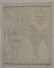
1. ‘New and Improved Map OF VARIOUS ROUTES BETWEEN EUROPE AND INDIA Comprehending WESTERN AND NORTHERN ASIA, TOGETHER WITH ASIA MINOR AND EGYPT BY J.B. TASSIN’ Contributor: Jean-Baptiste Athanase Tassin (publisher) Date: 1834/1834 Language: English Geographic region: AfricaAsiaEurope Extent: 1 map
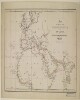
2. 'Map of routes from Europe to Upper India and Central Asia via Red Sea, the Euphrates Valley, and Kurrachee’ Date: 1845/1855 Language: English Geographic region: EuropeAfricaAsia Extent: 1 map sheet
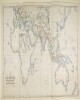
3. ‘MAP SHOWING THE STEAM COMMUNICATION AND OVERLAND ROUTES between ENGLAND, INDIA, CHINA & AUSTRALIA. Drawn & Engraved by J. Walker’ Contributor: William H Allen and Company, booksellers and publishers, London (publisher) Date: 1853/1853 Language: English Geographic region: EuropeAsiaAfricaAustralia Extent: 1 map
4. Kharīdat al-ʻajāʼib wa farīdat al-gharāʼib Creator: Ibn al-Wardī, Zayn al-Dīn ʻUmar ibn al-Muẓaffarابن الوردي, زين الدين عمر بن المظفر Contributor: Badahlī al-Shāfiʻī, Aḥmad ibn Muḥammad ibn ʻAbd al-Dāʼim, scribeIbn al-Habbārīyah, Muḥammad ibn MuḥammadDīrīnī, ʻAbd al-ʻAzīzḤarrānī, Aḥmad ibn Ḥamdānبدهلي الشافعي, احمد بن محمد بن عبد الدائم, ناسخابن الهبارية, محمد بن محمدديريني, عبد العزيزحراني, أحمد بن حمدان Date: 1582]. Language: Arabic Geographic region: AsiaAfricaSpainIslamic Empire Extent: 193 leaves : paper ; 160 x 125 (125 x 85) mm. bound to 160 x 130 mm.
5. SRTM30 enhanced global map : Slope Date: 2003 Geographic region: EarthEastern HemisphereWestern HemisphereNorthern HemisphereSouthern HemisphereAfricaAsiaAustraliaEuropeNorth AmericaSouth AmericaPolar regions180.00000090.000000-90.000000-180.000000 Extent: E. Rodríguez, et. al
6. World Map Showing Routes of Exploration and Discovery, 1850 (Raster Image) Date: 200911 Geographic region: EarthNorthern HemisphereSouthern HemisphereEastern HemisphereWestern HemisphereAfricaAsiaAustraliaEuropeNorth AmericaSouth AmericaArctic regions180.00000086.438634-84.990843-180.000000
7. World Map Showing Routes of Exploration and Discovery, 1853 (Raster Image) Date: 200910 Geographic region: EarthNorthern HemisphereSouthern HemisphereEastern HemisphereWestern HemisphereAfricaAsiaAustraliaEuropeNorth AmericaSouth AmericaArctic regions180.00000082.204539-82.110711-180.000000
8. World Map, 1654 (Raster Image) Date: 201404 Geographic region: EarthNorthern HemisphereSouthern HemisphereEastern HemisphereWestern HemisphereAfricaAsiaAustraliaEuropeNorth AmericaSouth AmericaArctic regions18090-90-180
9. World Map, 1725 (Image 2 of 2) (Raster Image) Date: 200910 Geographic region: EarthEastern HemisphereAfricaAsiaAustraliaEuropeSouth AmericaArctic regions171.98918283.865163-68.289741-65.093564
10. World Map, 1801 (Raster Image) Date: 200901 Geographic region: EarthNorthern HemisphereSouthern HemisphereEastern HemisphereWestern HemisphereAfricaAsiaAustraliaEuropeNorth AmericaSouth AmericaArctic regions180.00000084.263421-78.259774-180.000000
11. World Map, ca. 1774 (Raster Image) Date: 200910 Geographic region: EarthNorthern HemisphereSouthern HemisphereEastern HemisphereWestern HemisphereAfricaAsiaAustraliaEuropeNorth AmericaSouth AmericaArctic regions180.00000084.976331-76.321183-180.000000
12. Ḥadāʼiq al-siyāḥah Creator: Shīrvānī, Zayn al-ʻĀbidīnشيروانى، زين العابدين Contributor: Nuttall, Frank E., former owner Date: [1857]. Language: Persian Geographic region: AfricaAsiaMiddle EastIslamic countries Extent: 287 leaves : paper ; 355 x 215 (270 x 155) mm.