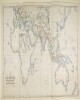
1. ‘MAP SHOWING THE STEAM COMMUNICATION AND OVERLAND ROUTES between ENGLAND, INDIA, CHINA & AUSTRALIA. Drawn & Engraved by J. Walker’ Contributor: William H Allen and Company, booksellers and publishers, London (publisher) Date: 1853/1853 Language: English Geographic region: EuropeAsiaAfricaAustralia Extent: 1 map
2. PZ 5662/1939 'Treatment of Enemy Consuls in British territory, other than India, on the outbreak of war' Contributor: Governor of Burma (correspondent)Government of Southern Rhodesia (correspondent)Government of the Union of South Africa (correspondent)Government of New Zealand (correspondent)Government of the Commonwealth of Australia (correspondent)Government of Canada (correspondent)Secretary of State for the Colonies, United Kingdom (correspondent)Secretary of State for India and Burma, United Kingdom (correspondent)Indian Political Service, External Affairs Department (recipient)Dominions Office (correspondent) Date: 1939/1939 Language: English Geographic region: Southern RhodesiaNew ZealandCanadaBurmaIndiaAustralia Extent: 1 file (53 folios)