1. '"Situation in Middle East" (Note by Major Bray, Political Intelligence Officer, attached to India Office)' Contributor: Norman Napier Evelyn Bray (author) Date: 1920/1920 Language: English Geographic region: PersiaTurkeyMesopotamiaRussian Soviet Federative Socialist RepublicMiddle East Extent: 1 file (15 folios)
2. 'Germany and the Middle East' Contributor: Secretary of State for India, United Kingdom (author) Date: 1915/1915 Language: English Geographic region: GermanySuez CanalTurkeyMiddle East Extent: 1 folio
3. ‘Fig. 14. Geological Sketch Map of Mesopotamia and the Adjacent Regions’ Date: 1918/1918 Language: English Geographic region: Middle East Extent: 1 map
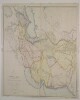
4. ‘Fig. 8. Distribution of the Chief Recorded Mineral Localities in Persia, Armenia, and Mesopotamia’ Date: 1918/1918 Language: English Geographic region: Middle East Extent: 1 map
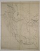
5. ‘Fig. 9. Distribution of Oil Springs and Bituminous Deposits of Mesopotamia and the Persian Gulf’ Date: 1918/1918 Language: English Geographic region: Middle East Extent: 1 map
6. 'The Muntafik. Al Sa'dun, Bani Malik, Ajwad, Bani Sa'id, Bani Huchaim' Contributor: Cairo Intelligence Department, Arab Bureau, Basra Branch (author) Date: 1917/1917 Language: English Geographic region: IraqMiddle East Extent: 1 file (87 folios)
7. 'Mesopotamia and Middle East: Question of Future Control' Contributor: Secretary of State for India, United Kingdom (author) Date: 1920/1920 Language: English Geographic region: MesopotamiaMiddle East Extent: 1 file (2 folios)
8. 'Ext 5697/42 General Hurley, USA Minister to New Zealand: tour of Middle East, Russia, etc' Contributor: British Embassy (correspondent)Foreign Office (correspondent)Secretary of State for India and Burma, United Kingdom (correspondent)Indian Political Service, External Affairs Department (correspondent)HM Ambassador to Egypt (correspondent) Date: 1942/1942 Language: English Geographic region: Middle East Extent: 1 file (14 folios)
9. ‘Map of the Countries lying between the Euphrates and Indus on the East and West, and the Oxus and Terek and Indian Ocean on the North and South. By John Macdonald Kinneir’ Contributor: Sir Knight John Kinneir Macdonald (author)Aaron Arrowsmith (author)Andrew Scott Waugh (author) Date: 1856/1856 Language: English Geographic region: Middle East Extent: 1 map on 4 sheets
10. ‘Map of the Countries lying between the Euphrates and Indus on the East and West, and the Oxus and Terek and Indian Ocean on the North and South. By John Macdonald Kinneir’ Contributor: Aaron Arrowsmith (publisher)Sir Knight John Kinneir Macdonald (publisher) Date: 1832/1832 Language: English Geographic region: Middle East Extent: 1 map on 16 sheets
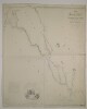
11. ‘Map of the countries between the Mediterranean Sea and the Gulf of Persia on the line of the Euphrates, Tigris, Kuran. Compiled and drawn by Lieut. Felix Jones J.N. Assist. Surveyor, from the original Surveys made by the late expedition under Commander H. Blosse Lynch assisted by Leutts. Chris D. Campbell M.W. Lynch, Felix Johnes, William B. Selby & Henry Grounds of the Indian Navy’ Contributor: James Felix Jones (surveyor) Date: 1847/1847 Language: English Geographic region: Middle East Extent: 1 map sheet
12. ‘Sketch of the Roads Between Constantinople and Dehli compiled from the Travels of Monsr. Tavernier Mr Forster and from other Sources’ Date: 1813/1813 Language: English Geographic region: Middle East Extent: 1 map sheet