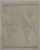
1. ‘New and Improved Map OF VARIOUS ROUTES BETWEEN EUROPE AND INDIA Comprehending WESTERN AND NORTHERN ASIA, TOGETHER WITH ASIA MINOR AND EGYPT BY J.B. TASSIN’ Contributor: Jean-Baptiste Athanase Tassin (publisher) Date: 1834/1834 Language: English Geographic region: AfricaAsiaEurope Extent: 1 map
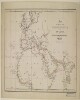
2. 'Map of routes from Europe to Upper India and Central Asia via Red Sea, the Euphrates Valley, and Kurrachee’ Date: 1845/1855 Language: English Geographic region: EuropeAfricaAsia Extent: 1 map sheet
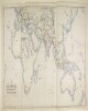
3. ‘MAP SHOWING THE STEAM COMMUNICATION AND OVERLAND ROUTES between ENGLAND, INDIA, CHINA & AUSTRALIA. Drawn & Engraved by J. Walker’ Contributor: William H Allen and Company, booksellers and publishers, London (publisher) Date: 1853/1853 Language: English Geographic region: EuropeAsiaAfricaAustralia Extent: 1 map
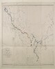
4. ‘Sketch map reduced from Sir R.M. Stephenson’s Railway map of Europe and Asia in 1850 and of China in 1863 Shewing the Proposed Railway Communication Connecting Europe and Asia. By Sir Rowland Macdonald Stephenson. 1882’ Contributor: Sir Rowland Macdonald Stephenson (surveyor) Date: 1882/1882 Language: English Geographic region: EuropeAsia Extent: 1 map
5. Analecta, Syro-Graeca Contributor: Collector: Kraus, Paul, 1904-1944Compiler: American University in Cairo. Rare Books and Special Collections Library Date: 1960; 1961; 1962; 1963; 1964; 1965; 1966; 1967; 1968; 1969; 1970; 1971; 1972; 1973; 1974; 1975; 1976; 1977; 1978; 1979; 1980; 1981; 1982; 1983; 1984; 1985; 1986; 1987; 1988; 1989 Language: GermanEnglishFrenchItalianLatin Geographic region: GreeceEuropeSyriaAsia Medium: indexes (reference sources) Extent: 16.6 x 21 cm.; 1 p.
6. Analecta, Syro-Graeca Contributor: Collector: Kraus, Paul, 1904-1944Compiler: American University in Cairo. Rare Books and Special Collections Library Date: 1960; 1961; 1962; 1963; 1964; 1965; 1966; 1967; 1968; 1969; 1970; 1971; 1972; 1973; 1974; 1975; 1976; 1977; 1978; 1979; 1980; 1981; 1982; 1983; 1984; 1985; 1986; 1987; 1988; 1989 Language: GermanItalianLatin Geographic region: GreeceEuropeSyriaAsia Medium: indexes (reference sources) Extent: 16.6 x 21 cm.; 3 p.
7. Indian Ocean Region, ca. 1690 (Raster Image) Date: 201110 Geographic region: AfghanistanAlgeriaAngolaArmeniaAustraliaAzerbaijanBahrainBangladeshBhutanBotswanaBritish Indian Ocean TerritoryBruneiBurmaBurundiCambodiaCameroonCentral Africian RepublicChadChinaChristmas IslandCocos (Keeling) IslandsComorosCongo, Democratic Republic of theCongo, Republic of theDjiboutiEgyptEritreaEthiopiaGabonGlorioso IslandsGuamIndiaIndonesiaIranIraqIsraelJapanJordanJuan de Nova IslandKazakhstanKenyaKuwaitKyrgyzstanLaosLesothoLibyaMadagascarMalawiMalaysiaMaldivesMauritiusMayotteMozambiqueNamibiaNepalNigerNigeriaNorth KoreaNorthern Mariana IslandsOmanPakistanPalauPapua New GuineaPhilippinesQatarReunionRwandaSaudi ArabiaSeychellesSingaporeSomaliaSouth AfricaSouth KoreaSri LankaSudanSwazilandSyriaTajikistanTanzaniaThailandTimor-LesteTurkeyTurkmenistanUgandaUnited Arab EmiratesUzbekistanVietnamYemenZambiaZimbabweIndian OceanAsiaSouth AsiaSoutheast AsiaAfrica, East177.31452253.283629-65.180727-13.682351
8. Iranica I Contributor: Collector: Kraus, Paul, 1904-1944Compiler: American University in Cairo. Rare Books and Special Collections Library Date: 1960; 1961; 1962; 1963; 1964; 1965; 1966; 1967; 1968; 1969; 1970; 1971; 1972; 1973; 1974; 1975; 1976; 1977; 1978; 1979; 1980; 1981; 1982; 1983; 1984; 1985; 1986; 1987; 1988; 1989 Language: ArabicGermanEnglishFrenchItalian Geographic region: IranAsia Medium: indexes (reference sources) Extent: 16.6 x 21 cm.; 2 p.
9. Iranica II Contributor: Collector: Kraus, Paul, 1904-1944Compiler: American University in Cairo. Rare Books and Special Collections Library Date: 1960; 1961; 1962; 1963; 1964; 1965; 1966; 1967; 1968; 1969; 1970; 1971; 1972; 1973; 1974; 1975; 1976; 1977; 1978; 1979; 1980; 1981; 1982; 1983; 1984; 1985; 1986; 1987; 1988; 1989 Language: ArabicGermanEnglishLatin Geographic region: IranAsia Medium: indexes (reference sources) Extent: 16.6 x 21 cm.; 3 p.
10. Kharīdat al-ʻajāʼib wa farīdat al-gharāʼib Creator: Ibn al-Wardī, Zayn al-Dīn ʻUmar ibn al-Muẓaffarابن الوردي, زين الدين عمر بن المظفر Contributor: Badahlī al-Shāfiʻī, Aḥmad ibn Muḥammad ibn ʻAbd al-Dāʼim, scribeIbn al-Habbārīyah, Muḥammad ibn MuḥammadDīrīnī, ʻAbd al-ʻAzīzḤarrānī, Aḥmad ibn Ḥamdānبدهلي الشافعي, احمد بن محمد بن عبد الدائم, ناسخابن الهبارية, محمد بن محمدديريني, عبد العزيزحراني, أحمد بن حمدان Date: 1582]. Language: Arabic Geographic region: AsiaAfricaSpainIslamic Empire Extent: 193 leaves : paper ; 160 x 125 (125 x 85) mm. bound to 160 x 130 mm.
11. King Herod I and the Family Language: Arabic Geographic region: Judaea (historical region)IsraelAsia Medium: manuscripts (document genre) Extent: 258 p.; 24 x 16.5 cm.
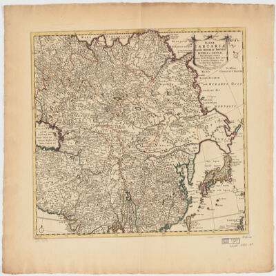
12. Magnae Tartariae, magni Mogolis Imperii, Iaponiae et Chinaenova descriptio ex tabula Creator: Wit, Frederik de. (المنشئ) Date: Date Issued: [ca. 1725?] Language: Latin Geographic region: Place of Production: ne, Netherlands, AmstelodamiAsia Extent: 1 map : hand col. ; 41 x 52 cm.