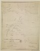
1. ‘Übersichts – Karte Von Iran, Oder West-Hochasien’ Date: 1852/1852 Language: German Geographic region: Iran Extent: 1 map
2. ‘Route from Isfahan by Kermanshah to Muraga and return by Hamadan. Performed under Orders of Brigr. Genl. Malcolm by Lieut. E. Frederick of the Bombay Military Establishmt. AD. 1810’ Contributor: John Garstin (signer) Date: 1810/1810 Language: EnglishLatin Geographic region: Iran Extent: 1 map sheet
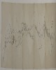
3. ‘Capt C. at Marshag. May 22nd 71’ Contributor: Jeffery Charles Amherst (artist) Date: 1871/1871 Language: English Geographic region: AdenCentral AsiaAvaBengalBombayBrazilBurmaCanadaCantonCentral IndiaChinaDelhiFort WilliamHong KongHyderabad StateIndiaIranIrelandJavaMadagascarMadrasMalaccaNagpurOudhPenangPhilippinesRajputanaRamreeRussiaShahpurSicilySingaporeBharatpur Extent: 1 drawing; pencil on paper, pasted into volume
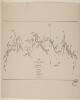
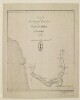
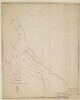
4. ‘Route map of the special mission to Seistan and Mekran, from Ispahan to Gwadur by Quarter Master Sergeant David Bower, Royal Engineers. To accompany the Journal of Capn. C. Bean Euan Smith, Personal Assistant to Major-General J.T. Goldsmid, C.B.’ Contributor: Trelawney William Saunders (publisher) Date: 1872/1872 Language: English Geographic region: Iran Extent: 1 map sheet
5. ‘Route map of the special mission to Seistan and Mekran, from Ispahan to Gwadur by Quarter Master Sergeant David Bower, Royal Engineers. To accompany the Journal of Capn. C. Bean Euan Smith, Personal Assistant to Major-General J.T. Goldsmid, C.B.’ Contributor: Trelawney William Saunders (publisher) Date: 1872/1872 Language: English Geographic region: Iran Extent: 1 map sheet
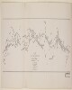
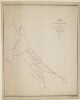
6. ‘Route map of the special mission to Seistan and Mekran. By Quarter Master Sergeant David Bower, Royal Engineers’ Date: 1872/1872 Language: English Geographic region: Iran Extent: 1 map sheet
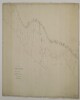
7. ‘Map of a route from Bushire to Bagdad Dedicated with submission to Captn. Sir Charles Malcolm R.N. By his Obedient Servant W.H. Wyburd I.N.’ Contributor: Charles Malcolm (dedicatee) Date: 1833/1833 Language: English Geographic region: IranIraq Extent: 1 map sheet
8. ‘Sketch of Lieutt. Snodgrass’s Route from Bushire to Shiraz, via Feruzabad, A.D. 1810’ Contributor: John Garstin (signer) Date: 1810/1810 Language: English Geographic region: Iran Extent: 1 map sheet
9. ‘Route of Lieut. McDonald 12th N.I. Ensign Monteith Engineers. Performed by Order of Brigadier General Malcolm Ambassador to the Court of Persia’ Contributor: John Garstin (signer) Date: 1806/1816 Language: English Geographic region: Iran Extent: 1 map sheet
10. ‘Route of Lieut. McDonald 12th N.I. Ensign Monteith Engineers. Performed by Order of Brigr. Genl. Malcolm Embassador to the Court of Persia. W. Monteith Ensgn Engineers' Contributor: John Garstin (signer) Date: 1811/1811 Language: English Geographic region: Iran Extent: 1 map sheet
11. 'Sketch Map of the Gulf of Persia' Date: 1863/1863 Language: English Geographic region: East AfricaArabian PeninsulaCentral AsiaBaroda StateIranKalat StateMysore StatePersian GulfRajputanaRiyadhRussiaSindUdaipur StateZanzibarGohadMuscat Extent: 1 map
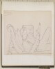
12. Fragment of wall painting: female with a mouth cover (padam) 8.27 x 9.61 in. (21.01 x 24.41 cm) Date: 600 - 700ca. 7th century A.D. Geographic region: IranKuh-i Khwaja Time period: Sasanian Medium: Stucco, paint, plaster Extent: 8.27 x 9.61 in. (21.01 x 24.41 cm)