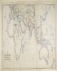
1. "خريطة تبين المواصلات بالزوارق البخارية والطرق البرية بين إنجلترا، الهند، الصين وأستراليا. رسم وطباعة ج. ووكر" المساهم: وليام هـ. ألين وشركاه (publisher) تاريخ المصدر: 1853/1853 اللغة: الإنجليزية المكان: أوروباآسياإفريقياأستراليا المدى الزمني: خريطة واحدة
2. Indian Ocean Region, ca. 1690 (Raster Image) تاريخ المصدر: 201110 المكان: AfghanistanAlgeriaAngolaArmeniaAustraliaAzerbaijanBahrainBangladeshBhutanBotswanaBritish Indian Ocean TerritoryBruneiBurmaBurundiCambodiaCameroonCentral Africian RepublicChadChinaChristmas IslandCocos (Keeling) IslandsComorosCongo, Democratic Republic of theCongo, Republic of theDjiboutiEgyptEritreaEthiopiaGabonGlorioso IslandsGuamIndiaIndonesiaIranIraqIsraelJapanJordanJuan de Nova IslandKazakhstanKenyaKuwaitKyrgyzstanLaosLesothoLibyaMadagascarMalawiMalaysiaMaldivesMauritiusMayotteMozambiqueNamibiaNepalNigerNigeriaNorth KoreaNorthern Mariana IslandsOmanPakistanPalauPapua New GuineaPhilippinesQatarReunionRwandaSaudi ArabiaSeychellesSingaporeSomaliaSouth AfricaSouth KoreaSri LankaSudanSwazilandSyriaTajikistanTanzaniaThailandTimor-LesteTurkeyTurkmenistanUgandaUnited Arab EmiratesUzbekistanVietnamYemenZambiaZimbabweIndian OceanAsiaSouth AsiaSoutheast AsiaAfrica, East177.31452253.283629-65.180727-13.682351
3. Oceania and Australasia, 1773 (Raster Image) تاريخ المصدر: 200905 المكان: Southern HemisphereAustraliaAustralasiaOceaniaPacific Ocean180.00000047.083860-70.929153-180.000000
4. Oceania, 1836 (Raster Image) تاريخ المصدر: 200911 المكان: OceaniaPacific OceanAustraliaSoutheast Asia180.00000046.786127-64.376995-180.000000
5. SRTM30 enhanced global map : Slope تاريخ المصدر: 2003 المكان: EarthEastern HemisphereWestern HemisphereNorthern HemisphereSouthern HemisphereAfricaAsiaAustraliaEuropeNorth AmericaSouth AmericaPolar regions180.00000090.000000-90.000000-180.000000 المدى الزمني: E. Rodríguez, et. al
6. World Map Showing Routes of Exploration and Discovery, 1850 (Raster Image) تاريخ المصدر: 200911 المكان: EarthNorthern HemisphereSouthern HemisphereEastern HemisphereWestern HemisphereAfricaAsiaAustraliaEuropeNorth AmericaSouth AmericaArctic regions180.00000086.438634-84.990843-180.000000
7. World Map Showing Routes of Exploration and Discovery, 1853 (Raster Image) تاريخ المصدر: 200910 المكان: EarthNorthern HemisphereSouthern HemisphereEastern HemisphereWestern HemisphereAfricaAsiaAustraliaEuropeNorth AmericaSouth AmericaArctic regions180.00000082.204539-82.110711-180.000000
8. World Map, 1654 (Raster Image) تاريخ المصدر: 201404 المكان: EarthNorthern HemisphereSouthern HemisphereEastern HemisphereWestern HemisphereAfricaAsiaAustraliaEuropeNorth AmericaSouth AmericaArctic regions18090-90-180
9. World Map, 1725 (Image 2 of 2) (Raster Image) تاريخ المصدر: 200910 المكان: EarthEastern HemisphereAfricaAsiaAustraliaEuropeSouth AmericaArctic regions171.98918283.865163-68.289741-65.093564
10. World Map, 1801 (Raster Image) تاريخ المصدر: 200901 المكان: EarthNorthern HemisphereSouthern HemisphereEastern HemisphereWestern HemisphereAfricaAsiaAustraliaEuropeNorth AmericaSouth AmericaArctic regions180.00000084.263421-78.259774-180.000000
11. World Map, ca. 1774 (Raster Image) تاريخ المصدر: 200910 المكان: EarthNorthern HemisphereSouthern HemisphereEastern HemisphereWestern HemisphereAfricaAsiaAustraliaEuropeNorth AmericaSouth AmericaArctic regions180.00000084.976331-76.321183-180.000000
12. سياسي (خارجي) ٥٦٦٢/١٩٣٩ "التعامل مع قناصل الأعداء في الأراضي البريطانية، باستثناء الهند، في أعقاب اندلاع الحرب" المساهم: حاكم بورما (correspondent)حكومة روديسيا الجنوبية (correspondent)حكومة اتحاد جنوب إفريقيا (correspondent)حكومة نيوزيلندا (correspondent)حكومة كومنولث أستراليا (correspondent)حكومة كندا (correspondent)وزير الدولة لشؤون المستعمرات (correspondent)وزير الدولة لشؤون الهند وبورما (correspondent)الخدمة السياسية الهندية، إدارة الشؤون الخارجية (recipient)مكتب الممتلكات (correspondent) تاريخ المصدر: 1939/1939 اللغة: الإنجليزية المكان: روديسيا الجنوبيةنيوزيلنداكندابورماالهندأستراليا المدى الزمني: ملف واحد (٥٣ ورقة)